ArcFM Desktop Developer Guide
Compatible Units
| ArcFM Desktop Overview > Designer Overview > Compatible Units |
ArcFM uses features to represent utility equipment, while Designer uses Compatible Units (CUs). Features are available in Designer on the Features tab. If you're working with designs and a Work Management System (WMS), however, you must use CUs on the CUs tab.
A CU has both parent and child layers. The parent layer holds the same attribute information as a feature. The child layer contains CU-defining attributes, metadata, and the information necessary to interact with the design and WMS. These are the same fields that are created when you use the ArcFM Object Converter to convert ArcFM objects to Designer objects. Features do not contain this information, so they cannot be used with a design.
Features can be used to update existing infrastructure without impacting the design. Assume, for example, that a designer wishes to swap out a transformer that is not represented on the map. The designer can place a feature to represent the existing transformer, then use a CU to replace it. The CU is added to the design while the feature is not.
Like many Work Management Systems, Designer uses the concept of CUs to aggregate equipment and the associated costs of construction. Designer operates with a CU Library which is defined by the implementer in the Designer geodatabase. In the practice of work management and job tracking, there exists a need to aggregate equipment and the costs associated with performing work tasks (installing, removing, moving, etc.) on the equipment. To this end, compatible units (CUs) represent a piece (or pieces) of equipment to be included in a job (design) and the associated costs of its inclusion in the design.
The installation and maintenance of equipment in the field has associated costs: the cost of the equipment, labor, permitting, etc.. All of these contribute to the cost of the design scenario. Because CUs merge the representation of the equipment with the equipment's associated costs, the use of CUs facilitates the accounting requirements of job tracking and design.
Many items included in a design scenario are not always mapped in the GIS. For example, the installation of a utility pole involves digging, anchoring, attaching hardware, and the possible installation of guys to overcome pole moment forces. The only items in this scenario that might be actually mapped are the pole feature itself and sometimes the guying equipment. The braces, insulators and other attachment equipment are not feasibly mapped in the GIS. It is important, however, to track these items and account for them in the work management environment. This is the goal of using CUs.
In the previous example, a wood pole CU could be constructed to represent the installation of a 40-foot, class 3 utility pole. Since poles are typically mapped in the GIS, this CU could be associated with a feature class in the geodatabase that represents utility poles and thus be mapped in the GIS. This is an example of a Symbolized CU.
Non-Symbolized GIS CUs are those that are not spatially represented in the GIS, yet are stored as objects in the geodatabase. These records are commonly related to features in the GIS. For example, distribution transformers are commonly modeled as a 'bank' where the mapped feature represents a group of transformer units. These transformer units are stored as rows in a transformer unit table and are related to an actual transformer bank feature. So, these transformer units are not mapped, but are stored in the GIS database.
Some items in the design scenario have attributes significant to accounting tasks only and do not need to be mapped in the GIS or stored as objects. For example, tree trimming is a design item that will likely not be mapped in the GIS but does have an associated cost that contributes to the cost of the design scenario. So, a Non-GIS CU is one that does not have an associated feature or object class to be stored in the GIS. It is significant only in the accounting aspects of work management.
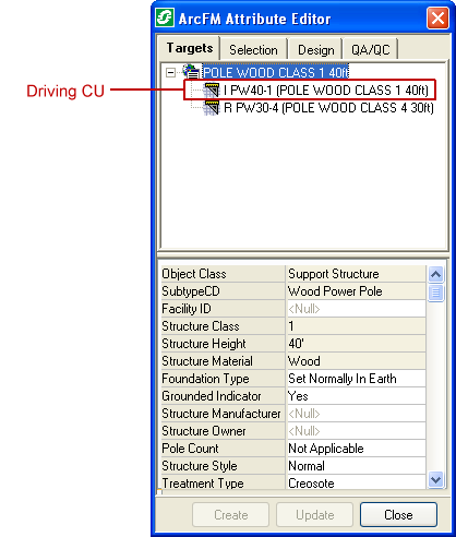
The GIS Unit (GU) displays the attributes of the driving Compatible Unit (CU), and the CU displays WMS information. In Figure 1, the Install is the driving CU (preceded with the letter I), so the parent layer (GU) displays its attributes.
Figure 1, driving CU
This section discusses the concept of CUs, how Designer works with them, and how to define a CU Library for use in the design environment.