The ArcFM Viewer Measure tool wraps Esri's Measure tool and provides the same functionality.
The Measure tool lets you draw on the map to measure lines and areas. You can use this tool in several ways. For example, you can draw a line or polygon on the map and get its length or area, or you can even click directly on a feature and get measurement information.
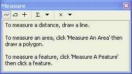
When you click the Measure tool, the Measure window appears. This dialog box allows you to set different options for how you measure, including whether to measure lines, areas, or features; and set which units are reported. Measurements are displayed inside the window, so it is easy to copy and paste them into other applications.
The Measure window contains tools for measuring distance and features. By default, the distance (line) measurement tool is enabled until you choose a different option from the Measure window.
 |
To disable snapping, hold down the spacebar when using the Measure Line or Measure An Area tools . |
The tools on the Measure window are listed below:
 Measure a line. Double-click to complete the line.
 Measure a polygon automatically. Double-click to complete the polygon.
 Click a feature to measure its length (line), perimeter, and area (polygon or annotation) or x,y location (point features).
 Keep a sum of consecutive measurements.
 Set the distance and area measurement units. The measure units are set to the map units by default.
 Clear the measurements.
 Choose measurement type. You can select from planar, geodesic, loxodrome, and great eliptic.
Additional information about the Measure tool is available in the Esri online documentation.

