
ArcFM Server Developer Guide
Locate
Version: 10.2.1d and 10.2.1d SP3 |
| ArcFM Server Overview > REST API > Locate |
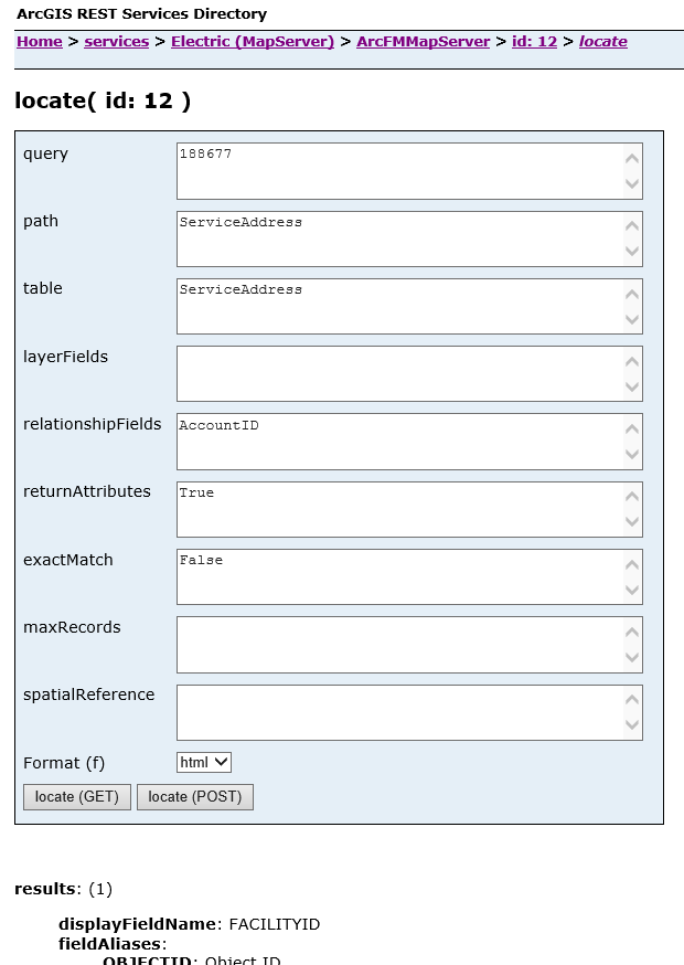
This operation allows you to perform a search on the selected layer or a related object to the selected layer. Note that in the example below the Relationship Path field originates with the selected layer (Service Point). A user could also select the Fuse layer and do a search on a field (or multiple fields) on this feature class. In this case, the Relationship Path and Table fields would be Null.
The parameters in the form correspond to parameters in the resulting URI. For example:
query=188677&
path=ServiceAddress&
table=ServiceAddress&
layerFields=&
relationshipFields=AccountID&
returnAttributes=True&
exactMatch=False&
maxRecords=500&
spatialReference=&
f=html
The image below shows a portion of the form with the corresponding portions of the URI.
Set the parameters and click Locate to start the operation. Results are displayed under the form. The following table describes the available parameters as well as valid values.
| Property | Description | Valid Values |
|---|---|---|
|
query |
This is the value for which you're searching. |
Any searchable value |
|
path |
This is necessary only if you're searching for a particular value on a related object. This field would contain the path to the related table. If the path is multiple relationships deep, it should be comma deliminated. It must also contain the table owner (case-sensitive). The example below allows you to search the CustomerInformation table. ARCFM.ServicePoint_ServiceAddress,ARCFM.ServiceAddress_CustomerInfo The path value is dependent on the order. In the example above, the ultimate goal is to reach CustomerInfo. We have to start with the ServicePoint_ServiceAddress relationship, then traverse to the ServiceAddress_CustomerInfo relationship to arrive at CustomerInfo. In any other order, we wouldn't traverse the path correctly and wouldn't arrive at CustomerInfo. |
Any valid relationship path with table owner |
|
table |
This is necessary only if you're searching for a particular value on a related object. This field contains the related table to be searched. Using the example in the path description, the table to be searched would be: ARCFM.CustomerInfo. The table name must be the full table name exactly as it appears in the geodatabase (case-sensitive). |
Any valid table name with the table owner. |
|
layerFields |
A comma-deliminated list of layer field names to be searched. |
Any valid field names |
|
relationshipFields |
A comma-deliminated list of relationship field names to be searched. |
Any valid field names |
|
returnAttributes |
Indicates whether to return attribute values with the results. |
True or False |
|
exactMatch |
Indicates whether to accept only the results that are an exact match to the criteria. |
True or False |
|
maxRecords |
Indicates the maximum number of records to be returned. |
Any positive, whole number |
|
spatialReference |
Use this parameter to specify a spatial references for the results. By default, the results use the spatial reference in the map document used by the map service. |
Any valid spatial reference value Valid format: {WKID:4326} |
|
Format |
Select the format used to return results. |
json or html |