ArcFM Server Developer Guide
Water Trace
Version: 10.2.1c and 10.2.1c SP3 |
| ArcFM Server Overview > REST API > Water Trace |
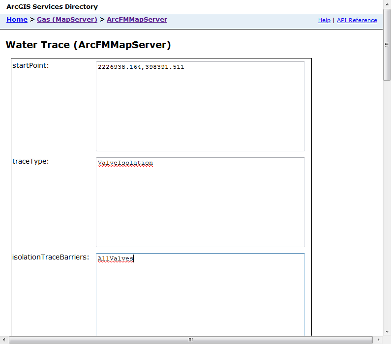
Use the Water Trace link to access the ArcFM Water Trace functionality and gather a specific results set. The parameters in the form correspond to parameters in the resulting URI. Some of the parameters listed below require EID values. Use the GetNetworkEID tool to retrieve these values.
http://dufek/ArcGIS/rest/services/Gas/MapServer/exts/ArcFMMapServer/Water%20Trace?
startPoint=2226938.164%2C398391.511&
traceType=ValveIsolation&
isolationTraceBarriers=AllValves&
excludedValves=&
includedValves=&
squeezeOffs=&
usePressures=True&
drawComplexEdges=False&
includeEdges=True&
includeJunctions=True&
returnAttributes=False&
returnGeometries=False&
tolerance=10&
spatialReference=&
f=pjson
The image below shows a portion of the form with the corresponding portions of the URI.
Set the parameters and click Water Trace to start the trace. The following table describes the available parameters as well as valid and default values.
 |
The startPoint field accepts an XY value as shown in the image above as well as a value in json format. For example: {x:2213252.324, y:397683.849} This format also allows you to indicate a spatial reference. For example: {x:2213252.324, y:397683.849, spatialReference:{WKID:4326}} |
|
Property |
Description |
Valid Values |
URI Values |
Default Value |
|---|---|---|---|---|
|
startPoint |
An XY value indicating the start of the trace. |
Any valid XY value. This value must reside in the same coordinate system as the one used by the map. |
Null |
|
|
traceType |
A value indicating the type of trace to be performed. |
Valve Isolation, Cathodic Protection, Pressure System
|
ValveIsolation, CathodicProtection, PressureSystem |
Valve Isolation |
|
isolationTraceBarriers |
Used only by the Valve Isolation trace. A value indicating the devices that act as barriers to the Valve Isolation trace. |
All Valves, Critical Valves |
AllValves, CriticalValves |
All Valves |
|
excludedValves |
Used only by the Valve Isolation trace. EID values indicating the valves that must be excluded from the trace. |
One or more valid EID values. If there are multiple, use a comma-deliminated list. |
Null |
|
|
includedValves |
Used only by the Valve Isolation trace. EID values indicating the valves that may be included in the trace. |
One or more valid EID values. If there are multiple, use a comma-deliminated list. |
Null |
|
|
squeezeOffs |
Used only by the Valve Isolation trace. EID values indicating the valves that act as squeeze off points. |
One or more valid EID values. If there are multiple, use a comma-deliminated list. |
Null |
|
|
usePressures |
Used only by the Valve Isolation trace. A checkbox that indicates whether to use pressures when isolating a specific area of the network. When this checkbox is selected, Valve Isolation uses pressure to locate the source (e.g., regulator station), then traces back to identify the valves that cut the selected portion of the network off from its source. When this checkbox is NOT selected (default setting), Valve Isolation identifies the valves closest to the area to be isolated. |
True, False |
True, False |
False |
|
pressureSystemTraceBarriers |
The barriers used for pressure system tracing. |
Water Regulators, Regulators and Other Devices |
WaterRegulators, RegulatorsAndOtherDevices |
Null |
|
drawComplexEdges |
A boolean value indicating whether the trace should draw complex edges. |
True, False |
True, False |
False |
|
includeEdges |
A boolean value indicating whether the user has identified edges to be included in the trace. |
True, False |
True, False |
True |
|
includeJunctions |
A boolean value indicating whether the user has identified junctions to be included in the trace. |
True, False |
True, False |
True |
|
returnAttributes |
A boolean value indicating whether to include attribute values in the trace results. |
True, False |
True, False |
False |
|
returnGeometries |
A boolean value indicating whether feature geometries are returned with the trace. |
True, False |
True, False |
True |
|
tolerance |
A numerical value indicating in map units the search tolerance for the trace. |
Any positive whole number |
Null |
|
|
spatialReference |
Use this parameter to specify a spatial references for the results. By default, the results use the spatial reference in the map document used by the map service. |
Any valid spatial reference value Valid format: {WKID:4326} |
Null | |
|
Format |
Select the format used to return results. |
json, html | json, html | json |