
ArcFM Server Developer Guide
Electric Trace
Version: 10.6.1 SP1 |
| ArcFM Server Overview > REST API > Electric Trace |
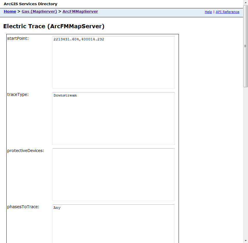
Use the Electric Trace link to access the ArcFM Electric Trace functionality and gather a specific results set. The parameters in the form correspond to parameters in the resulting URI. For example:
http://dufek/ArcGIS/rest/services/Gas/MapServer/exts/ArcFMMapServer/Electric%20Trace?
startPoint=2213431.604%2C400014.232&
traceType=Downstream&
protectiveDevices=&
phasesToTrace=Any&
drawComplexEdges=False&
includeEdges=True&
includeJunctions=True&
returnAttributes=False&
returnGeometries=True&
tolerance=100&
spatialReference=&
f=pjson
The image below shows a portion of the form with the corresponding portions of the URI.
Set the parameters and click Electric Trace to start the trace. Results are displayed under the form. The following table describes the available parameters as well as valid and default values.
 |
The startPoint field accepts an XY value as shown in the image above as well as a value in json format. For example: {x:2213252.324, y:397683.849} This format also allows you to indicate a spatial reference. For example: {x:2213252.324, y:397683.849, spatialReference:{WKID:4326}} |
|
Property |
Description |
Valid Values |
URI Values |
Default Value |
|||
|---|---|---|---|---|---|---|---|
|
startPoint |
An XY value indicating the start of the trace. |
Any valid XY value. This value must reside in the same coordinate system as the one used by the map. |
Null |
||||
|
traceType |
A value indicating the type of trace to be performed. |
Downstream, Upstream, Distribution, Downstream Protective, Upstream Protective, NextUpstreamProtective, ProtectiveIsolation |
Downstream, Upstream, Distribution, DownstreamProtective, UpstreamProtective, NextUpstreamProtective, ProtectiveIsolation |
Downstream |
|||
|
protectiveDevices |
A value indicating the protective devices that participate in the trace. | LayerID values corresonding to the protective device features | Null | ||||
|
phasesToTrace |
A value from the mmPhasesToTrace enumeration that indicates the phases to be included in the trace. |
Any, A, B, C, AB, AC, BC, ABC, At Least A, At Least B, At Least C, At Least AB, At Least AC, At Least BC, Any Single Phase, Any Two Phases |
Any, A, B, C, AB, AC, BC, ABC, AtLeastA, AtLeastB, AtLeastC, AtLeastAB, AtLeastAC, AtLeastBC, AnySinglePhase, AnyTwoPhases |
Any
|
|||
|
drawComplexEdges |
A boolean value indicating whether the trace should draw complex edges. |
True, False |
True, False |
False |
|||
|
includeEdges |
A boolean value indicating whether the user has identified edges to be included in the trace. |
True, False |
True, False |
True |
|||
|
includeJunctions |
A boolean value indicating whether the user has identified junctions to be included in the trace. |
True, False |
True, False |
True |
|||
|
returnAttributes |
A boolean value indicating whether to include attribute values in the trace results. |
True, False |
True, False |
False |
|||
|
returnGeometries |
A boolean value indicating whether feature geometries are returned with the trace. |
True, False |
True, False |
True |
|||
|
tolerance |
A numerical value indicating in map units the search tolerance for the trace. |
Any positive whole number |
Null |
||||
|
spatialReference |
Use this parameter to specify a spatial references for the results. By default, the results use the spatial reference in the map document used by the map service. |
Any valid spatial reference value Valid format: {WKID:4326} |
Null |
||||
| currentStatusProgID | Use this parameter to pass in a custom current status object. | Pass in the progID of the current status object | Null | ||||
|
Format |
Select the format used to return results. |
json, html | json, html | json | |||