
Version: 10.2.1c and 10.2.1c SP3 |
| Responder Overview > Responder Toolbar in ArcMap > Responder Weather Integration |
Available in ArcMap.
|
Beginning with version 10.2.1b, you can leverage real-time SE Weather Web Services information through Responder. If you do not yet have an account, you can start a free trial using the Start Free Weather Trial Start Free Weather TrialTo try the SE Weather Web Services integration with Responder:
|
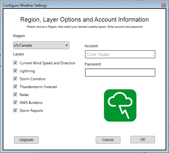
Once you have an SE Weather Web Services account, you can add weather layers to your map using the Select Weather Layers tool. Click the Select Weather Layers button to open the Configure Weather Settings window. The window contains three sections of information: Region, Layers, and Account Information.
Account Information
Enter the account name (email) and password for your account or free trial.
Region
Select either US/Canada or World from the drop-down list. The Region selection determines what layers are available.
Layers
Select the weather layers you want to load. The layers change based on the Region you select. All layers for each region are selected by default. You can deselect a layer to prevent it from being loaded.
 |
Each layer has a default visibility and visibility scale range set. Use standard ArcMap procedures to change these options. |
| Layer Group Name | Layers | Default Visibility |
| Current Wind Speed and Direction | Surface Observation Wind Speed (Miles Per Hour) | Enabled |
| Lightning | Cloud-to-Cloud - Last 15 Min Cloud-to-Ground - Last 15 Min |
Disabled Enabled |
| Storm Corridors | Heavy Rain Hail Dangerous Thunderstorms Possible Tornado |
Enabled Enabled Enabled Enabled |
| Thunderstorm Forecast | 1 Hour North America Thunderstorm Forecast | Group disabled |
| Radar | US Radar - Current Canadian Radar - Current |
Enabled Enabled |
| NWS Bulletins (US/Canada region only) | US NWS Bulletins - Warnings US NWS Bulletins - Watches US NWS Bulletins - Advisories US NWS Bulletins - Warning Area Maximum Impact US NWS Bulletins - Advisory Area Maximum Impact |
Group disabled |
| Storm Reports (US/Canada region only) | Storm Reports for past 24 hours | Group disabled |
| EU Met Bulletins (World region only) | EUMETNET Bulletins Today - Very Dangerous EUMETNET Bulletins Today - Dangerous EUMETNET Bulletins Tomorrow - Very Dangerous EUMETNET Bulletins Tomorrow - Dangerous |
Group disabled |
