
Version: 10.2.1c and 10.2.1c SP3 |
| ArcFM Engine Overview > ArcFM Viewer for ArcGIS Engine > GPS Support > GPS Support Toolbar |
The GPS Support toolbar provides access to tools that let you interact with your GPS and display GPS points on the map display.
|
Tool |
Description |
|
Set connection parameters for a GPS receiver. |
|
|
Clear GPS Display |
Clears all GPS symbology displayed on the map. |
|
Display Options |
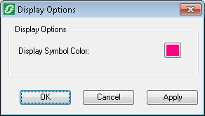
Allows you to determine the color of the GPS display symbology. Click the colored box (it shows the current selection) to display a color picker. Choose a color and select OK. Click OK on the Display Options dialog to save the change. 
|
|
|
Opens a connection to the GPS receiver. |
|
|
Closes the connection to the GPS receiver. |
|
|
When this button is toggled ON, the tool automatically pans to each GPS point. This tool will automatically zoom to the first point when GPS connection is opened. |
|
|
Zooms to the current GPS point. |
|
|
When this button is toggled ON, the tool automatically rotates the map so the direction of each GPS location is facing "up" in the map display. This button may only be toggled ON if the Auto Pan button is also ON. |