
| ArcFM Desktop Overview > Designer > Designer Basics > Compatible Units |
Compatible Units (CUs) may be placed on the map to represent specific utility equipment. A CU carries information about the feature or table it represents.
Typically a CU is made of two layers: the GIS unit (GU) and CU. The GU contains a reference to the object (or feature) class and subtype as well as the CU-defining attributes. The CU represents the feature and its WMS information (e.g., work function). A single GU may have multiple CUs (with various work functions).
There are three types of CU:
CU-Defining Attributes
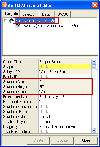
CU-defining attributes designate the features of that specific CU, a pole’s height and class, for example. CU-defining values are determined by your administrator. They are non-editable and displayed as gray on the Attribute Editor.

Figure 1, Note how the CU-defining attributes are reflected in the CUs name
Multiple CUs
A GU may have multiple CUs assigned to designate an upgrade, removal, or replace. For example, a GU may have a CU with an Install work function and a CU with a Remove work function to indicate that one is being removed and another installed (Replace).

Figure 2, GU with multiple CUs